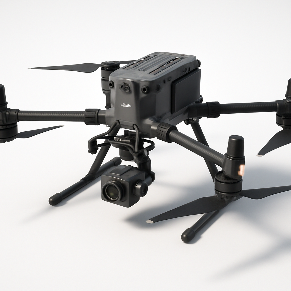
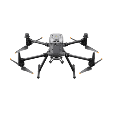
DJI Matrice 350 RTK
by DJI
Overview
The DJI Matrice 350 RTK represents the pinnacle of DJI's enterprise drone technology, specifically engineered for professional surveying, mapping, and industrial inspection applications. This flagship model builds upon the success of the Matrice 300 series, incorporating advanced RTK (Real-Time Kinematic) positioning technology that delivers centimeter-level accuracy for precision mapping and surveying workflows.
Designed for demanding commercial environments, the Matrice 350 RTK serves industries including construction, mining, agriculture, public safety, and infrastructure inspection. Its modular design allows operators to configure the aircraft with various payload combinations, making it adaptable to diverse mission requirements from photogrammetry surveys to thermal inspections and search-and-rescue operations.
The platform's robust construction and advanced flight control systems enable reliable operation in challenging conditions, while its comprehensive suite of intelligent features enhances both safety and operational efficiency for professional users.
Key Specifications
- Maximum flight time: Up to 55 minutes (no payload)
- Maximum horizontal speed: 23 m/s (51.4 mph)
- Maximum ascent speed: 6 m/s
- Maximum descent speed: 5 m/s
- Operating altitude: Up to 7,000m (relative to sea level)
- Wind resistance: Up to 15 m/s (Level 7)
- Operating temperature: -20°C to 50°C (-4°F to 122°F)
- IP rating: IP55 (aircraft body)
- Maximum payload: 2.7 kg (5.95 lbs)
- RTK positioning accuracy: Vertical ±1.5cm + 1ppm, Horizontal ±1cm + 1ppm
- Dual-gimbal support: Yes, with simultaneous operation
- Transmission range: Up to 15 km (9.3 miles)
- Battery capacity: TB65 Intelligent Flight Battery (5,880 mAh)
- Dimensions: 810×670×430 mm (unfolded), 365×215×430 mm (folded)
- Weight: 3.77 kg (8.31 lbs) without batteries
- Supported payloads: Zenmuse H20 series, L1, P1, XT2, Z30
Pricing & Configuration
The DJI Matrice 350 RTK starts at approximately $13,700 for the basic aircraft configuration, which includes the drone, remote controller, batteries, and essential accessories. However, the total investment typically ranges from $20,000 to $50,000 depending on payload selection and additional equipment requirements.
Payload options significantly impact the total cost, with professional cameras and sensors ranging from $5,000 to $15,000 each. The Zenmuse H20T (thermal and zoom camera) adds approximately $15,000, while the L1 LiDAR payload costs around $18,000. Enterprise customers often invest in multiple battery sets, charging hubs, and carrying cases, which can add several thousand dollars to the initial purchase.
DJI offers various support packages including DJI Care Enterprise, extended warranties, and training programs. Volume discounts and financing options are available for large enterprise deployments and government agencies.
Pros and Cons
Pros
- Exceptional flight endurance with up to 55 minutes of operation
- Centimeter-level RTK accuracy for precision surveying applications
- Dual-gimbal capability allows simultaneous data collection
- IP55 weather resistance enables operation in adverse conditions
- Comprehensive safety features including six-directional obstacle sensing
- Hot-swappable dual battery system for extended operations
- Advanced flight modes and automated mission planning
- Strong ecosystem of professional-grade payloads
Cons
- High initial investment cost compared to consumer alternatives
- Complex setup and operation requiring extensive training
- Heavy payloads significantly reduce flight time
- Limited compatibility with third-party sensors and cameras
- Requires RTK base station or network subscription for full accuracy
- Large size makes transportation and storage challenging
Who Should Buy This Drone?
The DJI Matrice 350 RTK is ideally suited for established commercial operators, surveying companies, construction firms, and government agencies that require professional-grade aerial data collection capabilities. Organizations conducting regular mapping, inspection, or monitoring operations will benefit most from the platform's advanced features and reliability.
Surveying and engineering companies performing topographic surveys, volumetric analysis, and construction progress monitoring will find the RTK accuracy and long flight times particularly valuable. Infrastructure inspection companies working on power lines, bridges, and industrial facilities will appreciate the dual-gimbal capability and weather resistance.
Public safety agencies, search and rescue organizations, and emergency responders can leverage the platform's thermal imaging capabilities and robust construction for critical operations. Large agricultural operations requiring precision crop monitoring and analysis will also benefit from the extended flight times and payload flexibility.
This drone is not recommended for casual users, small businesses with limited budgets, or operators who don't require centimeter-level accuracy. The complexity and cost make it unsuitable for simple aerial photography or recreational use.
Final Verdict
The DJI Matrice 350 RTK stands as one of the most capable enterprise drone platforms available, delivering exceptional performance for professional surveying, mapping, and inspection applications. While the significant investment and operational complexity may deter some users, the platform's combination of flight endurance, positioning accuracy, and payload flexibility makes it an excellent choice for serious commercial operations.
The RTK capabilities alone justify the premium for applications requiring precise georeferencing, while the dual-gimbal support and comprehensive safety features enhance operational efficiency and data quality. For organizations that can fully utilize its capabilities and justify the investment, the Matrice 350 RTK represents a solid long-term platform that can adapt to evolving mission requirements through its modular payload system.
Pros
- + Exceptional flight time up to 55 minutes
- + RTK centimeter-level accuracy
- + dual-gimbal support
- + IP55 weather resistance
- + comprehensive safety features
Cons
- - High initial cost
- - complex setup for beginners
- - heavy payload affects flight time
- - limited third-party payload compatibility
Compare DJI Matrice 350 RTK with
Frequently Asked Questions
What is DJI Matrice 350 RTK?
Professional enterprise drone platform designed for surveying, mapping, and industrial inspection applications. Features advanced RTK positioning, dual-gimbal capability, and robust flight performance in challenging environments.
How much does DJI Matrice 350 RTK cost?
DJI Matrice 350 RTK uses a modular pricing model with plans starting at $13,700.
What are the main advantages of DJI Matrice 350 RTK?
The key advantages of DJI Matrice 350 RTK include: Exceptional flight time up to 55 minutes; RTK centimeter-level accuracy; dual-gimbal support; IP55 weather resistance; comprehensive safety features.
What are the drawbacks of DJI Matrice 350 RTK?
Some limitations to consider: High initial cost; complex setup for beginners; heavy payload affects flight time; limited third-party payload compatibility.
What category does DJI Matrice 350 RTK belong to?
DJI Matrice 350 RTK is a Surveying & Mapping tool developed by DJI.
DJI Matrice 350 RTK Comparisons
WingtraOne Gen II vs DJI Matrice 350 RTK
Detailed comparison of WingtraOne Gen II and DJI Matrice 350 RTK — which one is the right drone for your operation?
DJI Matrice 350 RTK vs DJI Matrice 300 RTK
Detailed comparison of DJI Matrice 350 RTK and DJI Matrice 300 RTK — which one is the better choice for your operation?
Surveying & Mapping Guides
Best Drones for Construction Site Surveying in 2026
Best ToolsTop surveying drones for construction professionals. Compare RTK accuracy, BIM integration, volumetric analysis capabilities, and total cost of ownership for site surveys.
How to Choose a Survey Drone: RTK vs PPK vs Standard GPS
How to ChooseA practical guide to understanding RTK, PPK, and standard GPS accuracy for surveying drones. Learn which positioning technology fits your project requirements and budget.
How to Choose an Inspection Drone: The Complete Buyer's Guide
How to ChooseEverything you need to know before buying an inspection drone. From thermal vs. optical cameras to GPS-denied environments — a practical guide for infrastructure and industrial inspection teams.
Drone Regulations for Commercial Operators: 2026 Guide
How to ChooseA plain-language guide to commercial drone regulations in the US, EU, UK, and Australia. Covers Part 107, Open/Specific category, BVLOS waivers, and what's changing in 2026.
Other Surveying & Mapping Tools
View all 11 tools →American Robotics Scout System
American Robotics
The American Robotics Scout is a fully autonomous drone system designed for remote monitoring and data collection. It operates without human pilots through an automated base station, enabling continuous surveillance and inspection operations across various industries including energy, agriculture, and security.
Delair UX11
Delair
The Delair UX11 is a professional fixed-wing mapping drone designed for large-scale surveying and GIS applications. It offers exceptional flight endurance up to 59 minutes and can cover up to 450 hectares in a single flight with high-precision mapping capabilities.
DJI Phantom 4 RTK
DJI
A professional mapping drone with integrated RTK positioning system for centimeter-level accuracy surveying and photogrammetry. Features a 20MP camera with 1-inch CMOS sensor and D-RTK 2 high precision GNSS for precise geolocation of captured images.
JOUAV CW-15
JOUAV
The JOUAV CW-15 is a professional VTOL fixed-wing drone designed for large-scale surveying, mapping, and inspection operations. It combines the vertical takeoff capabilities of a quadcopter with the long-range efficiency of a fixed-wing aircraft, offering up to 2.5 hours of flight time and covering up to 1,000 hectares in a single mission.