WingtraOne Gen II
by Wingtra
Overview
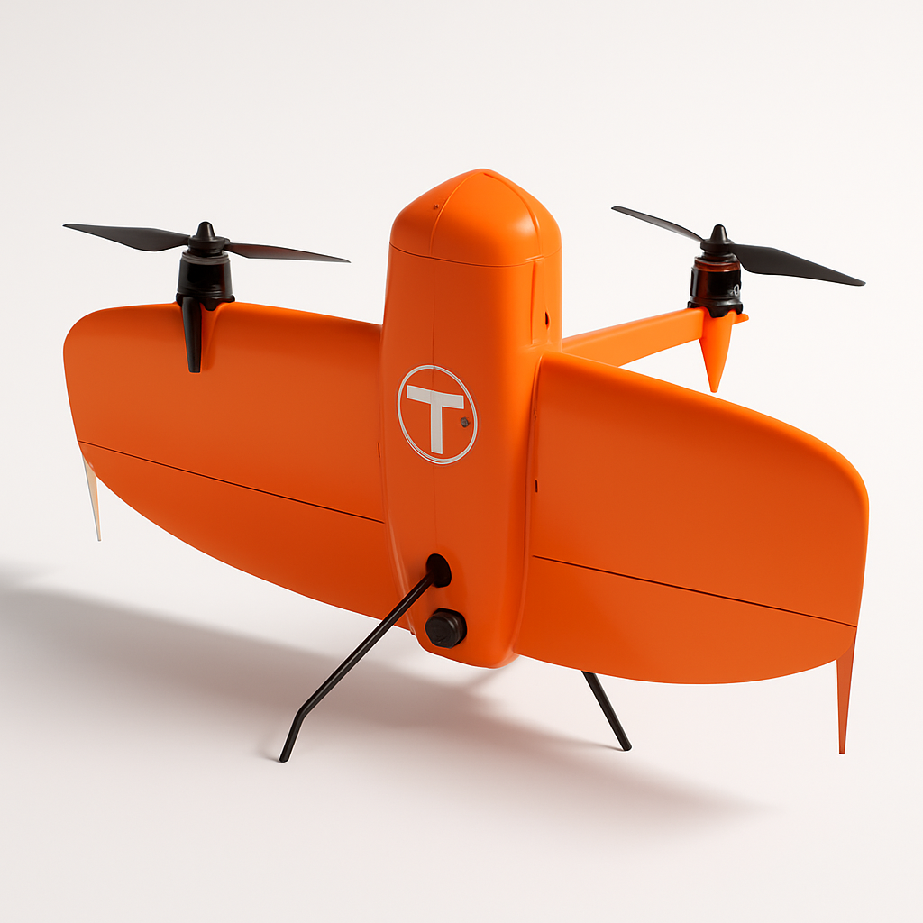
The WingtraOne Gen II represents a significant advancement in professional surveying and mapping technology, combining the operational convenience of vertical takeoff and landing with the efficiency and range of fixed-wing aircraft. Developed by Swiss company Wingtra, this hybrid drone is specifically engineered for surveyors, engineers, and GIS professionals who need to capture high-accuracy geospatial data over large areas.
What sets the WingtraOne Gen II apart from traditional mapping solutions is its unique tilt-rotor design that allows it to take off and land like a multirotor drone while transitioning to efficient forward flight like a fixed-wing aircraft. This eliminates the need for runways or large open spaces for launch and recovery, making it ideal for operations in constrained environments while still delivering the coverage and efficiency benefits of fixed-wing platforms.
The drone is positioned as a premium solution for professional mapping applications including construction site monitoring, mining operations, agriculture, environmental monitoring, and infrastructure inspection. Its focus on accuracy, reliability, and ease of use makes it particularly attractive to organizations that need consistent, high-quality results without the complexity typically associated with fixed-wing mapping systems.
Key Specifications
- Max flight time: 59 minutes
- Max coverage area: 240 hectares (593 acres) per flight
- Max wind resistance: 45 km/h (28 mph)
- Operating temperature: -10°C to +50°C (14°F to 122°F)
- Takeoff weight: 3.3 kg (7.3 lbs)
- Max payload: 500g (1.1 lbs)
- GPS accuracy: 3-5 cm with PPK processing
- RTK compatibility: Yes, real-time corrections
- Ground sample distance: Down to 0.7 cm/px at 120m altitude
- IP rating: Weather resistant design
- Camera options: Sony RX1R II (42MP), RedEdge-P multispectral, Sony A6000 series
- Control range: Up to 3 km with standard controller
- Automated flight planning: WingtraPilot software included
- Data processing: WingtraHub cloud processing platform
- Safety features: Return-to-home, geofencing, obstacle avoidance
- Certifications: CE marked, various aviation authority approvals
Pricing & Configuration
The WingtraOne Gen II follows an enterprise pricing model with packages starting around $38,000 USD. The base configuration includes the aircraft, ground control station, professional camera, flight planning software, and initial training. Different camera payload options are available depending on application needs, with multispectral and thermal imaging sensors commanding premium pricing.
Wingtra offers comprehensive support packages that include extended warranties, additional training, and priority technical support. The company also provides WingtraHub cloud processing credits as part of their service offerings, though additional processing capacity can be purchased as needed. Educational discounts and leasing options are available for qualifying institutions and organizations.
Pros and Cons
Pros:
- VTOL capability enables operations in confined spaces without runway requirements
- Exceptional coverage area and flight endurance for a VTOL platform
- High accuracy PPK/RTK processing delivers professional-grade results
- Weather resistant design allows operations in challenging conditions
- Comprehensive training and support ecosystem
- Automated flight planning reduces operational complexity
- Swiss engineering and build quality
Cons:
- Significant upfront investment limits accessibility for smaller operators
- Complex mechanical design requires more maintenance than simple multirotor platforms
- Limited payload flexibility compared to larger multirotor mapping drones
- Weather dependencies still limit operational windows
- Requires substantial training investment for optimal results
Who Should Buy This Drone?
The WingtraOne Gen II is ideally suited for established surveying companies, engineering firms, mining operations, and large agricultural enterprises that regularly need to map extensive areas with high accuracy. Organizations that have moved beyond entry-level mapping solutions and require the efficiency gains that come with fixed-wing platforms will find significant value in this system.
Construction companies managing large projects, environmental consultants conducting regular monitoring, and government agencies responsible for infrastructure management represent core target markets. The drone is particularly valuable for operations in remote or access-restricted areas where the VTOL capability provides significant operational advantages over traditional fixed-wing platforms.
Smaller operators or those just entering the professional mapping market may find the investment difficult to justify unless they have consistent, high-value projects that can support the premium pricing. The learning curve and operational requirements also make this more suitable for dedicated drone operators rather than occasional users.
Final Verdict
The WingtraOne Gen II delivers on its promise of combining VTOL convenience with fixed-wing efficiency, making it one of the most capable professional mapping platforms available today. The engineering quality, accuracy capabilities, and operational flexibility justify the premium pricing for organizations that can fully utilize its capabilities.
While the high upfront cost and operational complexity prevent it from being a universal solution, it represents an excellent choice for established professional users who need reliable, high-accuracy mapping capabilities across large areas. The comprehensive support ecosystem and continued product development from Wingtra provide confidence in the long-term viability of the platform.
For the right applications and operators, the WingtraOne Gen II offers a compelling balance of capability, efficiency, and operational flexibility that can significantly enhance productivity compared to both traditional fixed-wing and multirotor alternatives.
Pros
- + VTOL capability eliminates need for runway
- + High accuracy PPK/RTK processing
- + Large area coverage up to 240 hectares per flight
- + Weather resistant design
- + Professional support and training included
Cons
- - High initial investment cost
- - Complex operation requires training
- - Limited payload flexibility compared to multirotor drones
- - Weather dependent operations
Compare WingtraOne Gen II with
Frequently Asked Questions
What is WingtraOne Gen II?
The WingtraOne Gen II is a professional VTOL (vertical takeoff and landing) mapping drone designed for large-area surveying and inspection missions. It combines the convenience of vertical takeoff with the efficiency of fixed-wing flight, delivering high-precision mapping data with PPK/RTK accuracy.
How much does WingtraOne Gen II cost?
WingtraOne Gen II uses a enterprise pricing model with plans starting at $38,000.
What are the main advantages of WingtraOne Gen II?
The key advantages of WingtraOne Gen II include: VTOL capability eliminates need for runway; High accuracy PPK/RTK processing; Large area coverage up to 240 hectares per flight; Weather resistant design; Professional support and training included.
What are the drawbacks of WingtraOne Gen II?
Some limitations to consider: High initial investment cost; Complex operation requires training; Limited payload flexibility compared to multirotor drones; Weather dependent operations.
What category does WingtraOne Gen II belong to?
WingtraOne Gen II is a Surveying & Mapping tool developed by Wingtra.
WingtraOne Gen II Comparisons
WingtraOne Gen II vs DJI Matrice 350 RTK
Detailed comparison of WingtraOne Gen II and DJI Matrice 350 RTK — which one is the right drone for your operation?
WingtraOne Gen II vs senseFly eBee X
Detailed comparison of WingtraOne Gen II and senseFly eBee X — which one is the better choice for your operation?
Surveying & Mapping Guides
Best Drones for Construction Site Surveying in 2026
Best ToolsTop surveying drones for construction professionals. Compare RTK accuracy, BIM integration, volumetric analysis capabilities, and total cost of ownership for site surveys.
How to Choose a Survey Drone: RTK vs PPK vs Standard GPS
How to ChooseA practical guide to understanding RTK, PPK, and standard GPS accuracy for surveying drones. Learn which positioning technology fits your project requirements and budget.
Drone Regulations for Commercial Operators: 2026 Guide
How to ChooseA plain-language guide to commercial drone regulations in the US, EU, UK, and Australia. Covers Part 107, Open/Specific category, BVLOS waivers, and what's changing in 2026.
Other Surveying & Mapping Tools
View all 11 tools →American Robotics Scout System
American Robotics
The American Robotics Scout is a fully autonomous drone system designed for remote monitoring and data collection. It operates without human pilots through an automated base station, enabling continuous surveillance and inspection operations across various industries including energy, agriculture, and security.
Delair UX11
Delair
The Delair UX11 is a professional fixed-wing mapping drone designed for large-scale surveying and GIS applications. It offers exceptional flight endurance up to 59 minutes and can cover up to 450 hectares in a single flight with high-precision mapping capabilities.
DJI Matrice 350 RTK
DJI
Professional enterprise drone platform designed for surveying, mapping, and industrial inspection applications. Features advanced RTK positioning, dual-gimbal capability, and robust flight performance in challenging environments.
DJI Phantom 4 RTK
DJI
A professional mapping drone with integrated RTK positioning system for centimeter-level accuracy surveying and photogrammetry. Features a 20MP camera with 1-inch CMOS sensor and D-RTK 2 high precision GNSS for precise geolocation of captured images.